During the sailing ship era the passage around Cape Horn (Cabo de Hornos / Kap Hoorn / Cap de Horen) was considered as most risky and hazardous shipping route on world. Strong winds in South Atlantic and Southern Pacific, strong waves, icebergs and strong currents contributed to it´s fame as "sailing ships graveyard". European desaster registers count 800 lost ships and 10.000 persons buried by the ocean waves. Sailors yarn ? Who ever knows ... but having once crossed Cape Horn successfully was considered as baptism of fire for ship and crew.
Source : Condor
Cape Horn on Horn Island is the most southern point of the Americas continent
Source : esys.org
Before the construction of the Panama Channel in 1914, the ocean route around Fireland was the only navigable connection between Atlantic and Pacific Ocean, between Europe or North American Eastcoast and Chile, Peru or California.
The Cape Horn Route allowed three alternatives to avoid the direct passage around the dangerous cape, but only experienced ship crews and captains could risk the also dangerous navigation through the Strait of Magellhan or the Beagle Channel, close, natural passages through the rocky Fireland Island system that are situated 150 and 400 kilometers north from the Cape.
A third alternative existed with the voyage through the Firth of Nassau that separates the Wollastone and Hermite Islands Archipelagos with Cape of Horn from the northern Tierra del Fuego Archipelagos Hoste and Navarino Islands. The Nassau Bay is between 14 and 25 kilometers wide and presents less dangerous streaming than inside the much narrower Beagle and Magellhan passages but doesn´t necessarily guarantee more shelter from heavy seas as the Cape Horn passage itself.
Sattelite View over Tierra del Fuego with the 3 Straits
as alternative shipping routes to avoid the Cape Horn passage
Actually in the Tierra del Fuego region exist two geographical sites named Nassau and Orange, as far as known here, but the complete study of more detailled and over the whole historic period drawn maps probably would promote to daylight more places to which explorers and cartographers attributed these names. As known from Senegal Goree Island, the colonial and political changes also contributed from time to time to a dissappearance or exchange of "european" site namings in overseas. Not at least also must be considered, that native populations already attributed site names to "their" landscape that sometimes turned out as more established than the namings by alien intruders.
The case of an apparent dissappearance of a Cape Nassau and a Cape Orange in the Tierra del Fuego region can be studied 240 and 360 kilometers north of the here described Nassau Bay at the north coasts of the "Isla Grande de Tierra del Fuego" in the surroundings of the Atlantic entrance to the Magellhan Strait. There, east of the town Punta Arenas, the Cape Nassau extends towards the "Segunda Angostura" of the Magellhan Strait meanwhile 145 kilometers eastward the Cape Orange points inside the Atlantic Ocean, moulding the San Sebastian Bay.
Cape Nassau and Cape Orange, situated around the Magellhan Strait entrance,
as described by Dutch explorers and cartographers from the 1628 - 1633 period.
In 1635 Cape Orange "moved to north" (see downside)
On actual maps the ancient Cape Nassau can be found as PENINSULA JUAN MASÌA and the Orange Cape as PENINSULA DEL PARAMO. The original namings date in the 1620-1635 period.
The first "european" namegivings result from the exploring of the southern South American coast by Italian, Portuguese, British and Dutch sailors. Having established colonies in the Northamerican East Coast, Carribbean, Antillas, the Guayanas and Surinam the discovery and exploration of naval shipping routes towards the Pacific Ocean and Eastindia became priority for the European Trade Companies. Under the regency of Maurice I Prince of Orange and Nassau Dillenburg the so called "Nassausche Vloot" (Naval Squadron of Nassau) was sent out from Holland to gain control over the "Cono Sur" by mapping and establishing of contacts to the native inhabitants. The first results have been several maps of the southern continental coastline that became a successively more and more exact drawing of the geographical reality.
Obviously the Dutch maps where distributed in Europe so that cartographers from other countries maintained the Netherlands site names when they tried to draw their own, more detailled plans, but not necessarily remained coincident with the exact initial sites. So the parallel study of all existing nautical maps from the 17th century leads to certain confusion that only was dissolved by the advance of modern cartography.
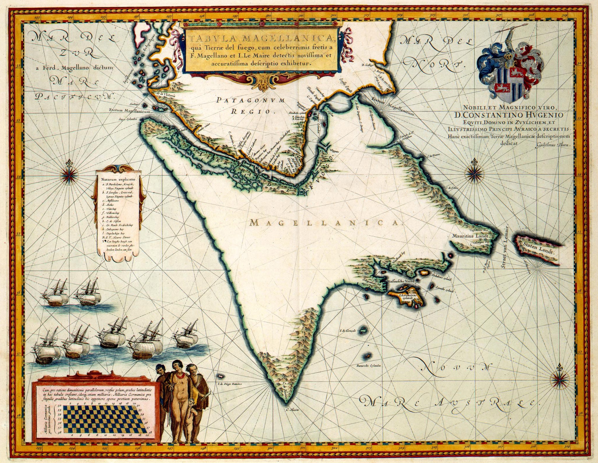
LES ISLES MAGELLANIQUES. Extract of a map of N. Sanson d´Abbeville, geograph ordre du roi a Paris 1656.
The much jounger french map draws a much lesser exact image as older Dutch maps, with a confusing second entrance to Magellhan Strait as San Sebastian Channel (probably the Beagle Channel) and the "Nassaw Canal" moved around Cape Horn towards the west.
The french map from 1656 don´t mention the Cape Nassau and Cape Orange around the Atlantic Magellhan Strait entrance. Both namings are repeated on maps attributed to the results of the Dutch Nassau Fleet expeditions. First and older citation is the FRETI MAGELLANICI map drawn by Jodocus Hondius around 1628 and probably is based on descriptions of Mr. Barent Lansz, Potgieter van Munster and Capiteyn Sebald de Waerd.
Cape Nassau and Orange at Magellhan Strait drawn 1628. Extract.
But meanwhile this first mapping describes rather exact the norther Tierra del Fuego area, in it´s southern descriptions it remains rather superficial. Here the NASSAU BAY is not already mentioned and the Beagle Channel is only outlined at it´s entrances but not as complete passage. This indicates, that the complete discovery, description and cartography of the Cape Horn surroundings ocurred at a later date, later than 1628.
The discovery and naming of the NASSAUSCHE VOERD (Firth of Nassau) is attributed to the expedition of Jacques l´Hermite, commander of the "Nassausche Vloot", who started from Goree (Netherlands) end of april 1623 with the ships Oranje, Haas, Wapen van Amsterdam, Arend, Koning David, Delft, Eendracht, Griffioen, Windhond, Hollandia and Hoop en Mauritius. In February 1624 the "Nassausche Vloot" reached the LeMaire Strait and the Beagle Channel Atlantic entrance.
The following discoveries are described in the Journalen van drie Voyagien edited in Amsterdam 1643 by Jacob Pietersz Wachter. Cartographical remains are the namings of the Firth of Nassau and the Goe Ree Bay or Peninsula (Navarino Island). Two sites received names of ships that participated in the expedition: The Orange Bay (Hardy Peninsula / Hoste Island) and the Windhond Bay and Windhond Lake (Navarino Island). As contribution to the leaders of expedition the Hermite Island west of Cape Horn and the Schapenhams Bay (Hardy Peninsula / Hoste Island) where named after Jacques l`Hermite and his viceadmiral Gheen Huygen Schapenham.
The more detailed coastline drawing with the new names appears on a second edition from 1633 of the upside mentioned Freti Magellanici map. The map is nearly identic with the edition from 1628, except the actualizations around the Cap Horn. As editor firms Hendrik Hondius, meanwhile the first edition cites Jodocus Hondius. The site attributions of Windhond Bay and Goe Ree (Bay or Peninsula ?) are not identic with the later indicated sites named so. The Windhond Bay actually describes a coast incision of Navarino Island, that initially was marked as Goe Ree. The nowadays Goree Channel also in ratio is moved east from it´s initial description site, due to the relocation of Windhond Bay. Same happens with Terhalten Island.
Second Edition from 1633 of Hondius´s Freti Magellanici map from 1628 with more detailled drawings of the Firth of Nassau and other new named sites.
This leads to the conclusion, that the Windhond Bay in 1624 initially was situated inside the nowadays Seno Grande called natural harbour formed by the Bertrand and Navarino Island. The next bay at Navarino Island southern coast towards the east received the description Goe Ree, without detailling on the map if it describes a Bay or an Peninsula. But in any way the description Goeree on the 1633 map named the nowadays so called Channel of Goree between Navarino and Lennox Island. Also the later Lennox Island on the 1633 map firms as Terhaltens Island, a name that nowadays describes a much smaller rock nearly 15 kilometers southward of Lennox in the ocean and that wouldn´t have been drawn so overdimensioned.
What could decipher the reasons for the coordinated and proporcional "moving towards the east" of the inital site names ?
The proper Firth of Nassau remained in it´s site, except on the upside cited french map from 1656. There it is to find approximately at the place, where the Netherland´s expedition founded the Schapenham´s Bay and drawn similar as a channel entrance, even if the add "canal" also could be attributed to the letters NICQ. If one assumes that the Nassau Canal / Schapenham Bay on that map from 1656 is situated on the western coast of the Hoste Island´s Hardy Peninsula, then the actual ORANGE BAY would be situated exactly on the peninsulas east coast. But why the ORANJE BAAI isn´t shown on any of the maps from the 17th century ?
The answer could bring a painting, better said an engraving from 1631 from the Netherlands that seems to be a document of the meeting of L´Hermite´s "Nassausche Vloot" with the native population of Tierra del Fuego in 1624. The ethnocultural study shows several groups of persons belonging to an indigenous tribe, sparsely dressed with children and weapons, some fishing from canoas around the scenery of a wooded ocean bay. The seaside of the bay apparently is blocked by a fleet of galeons from where boats approach. Some european dressed persons on a beach seem to be engaged in combats with the native people.
The 1624 L´Hermite Nassau Expedition meets the Yaghan natives
at the coasts of the Firth of Nassau in Tierra del Fuego.
A comparation of the landscape scenery of the historic engraving and the natural conditions in Orange Bay shows surprising similarities. Also the actual forest vegetation and mountain range sculpturing indicates, that the painted site could have been exactly that site that was named Orange Bay, but not mapped as that.
View from Hoste Island over the Orange Bay
So, what could have generated that confusion around not completely mentioned site names or the later moving of site names to somewhere else ? The upside mentioned Expedition Diary sheds light on an event, that probably marked strongly the later assessment of the complete discovery proyect. During the expedition in the Firth of Nassau area the ships crew lost 8 man that drowned gone overboard in a storm, meanwhile 6 others could be rescued from the ocean. Furthermore during a meeting with the Yaghan Indians 17 native where captured and brought to a ship where they where beaten to death. Another incident was the the arrest and death punishment of 5 netherland sailors that broke the ships hold, later they were pardoned. Again later 12 men for discipline problems where deferred from a ship onto an rock island, meanwhile a specific sentencing of the killing of the 17 Yaghan indians is not mentioned in the voyages journal (Source: Netherland Wikipedia. The spanish Wikipedia gives in January 2016 still a warped description of the meeting with Yaghan, where the Dutch sailors remained as "17 victims". The german Wikipedia repeats that version and details, that the "killed sailors" belonged to the "AREND" vessel).
For the commander of the fleet, the further voyage ended 4 month later in june 1624 in Peru. The ships returned in july 1626 to Texel in Holland. The task of the 11 ships with 1000 men crew and 600 soldiers on board had been the the assault and capturing of the spanish silver fleet.
As result of the expedition, that could be considered as an advance for the geographical science, emerged in 1635 a new map of the coastlines of the Tierra del Fuego or Patagonia region. As usually it distinguishes from all other maps, mostly because the "False Cap Horn" - on the map described as "Cap de Hooren" - is situated unproportionally more far to southwest away from it´s real site. Could that be an "unspoken protest" of the cartographer against the treatment of the Yaghan people that ocurred exactly in that "opened" cartographic space ?
A second change registeres also the 1635 map compared with the Hondius´s Freti Magellhanici maps from 1628 and 1633. The Cape Orange now is moved away from the "San Sebastian" Bay and exactly located at the first bottleneck of the Magellhan Strait, besides Cape Nassau, exactly where one would imagine it, but confusingly it carries as second name the description "Cabo de San Gregorio" meanwhile the former wrong channel entrance at it´s earlier mapping site is maintained as "Entrada de San Sebastian". A design fact that much more difficult could be understood.
As additional data could be mentioned here the indigenous SELKNAM tribe that lived exactly at that site, where initially Cape Orange seemed to be attributed to (Bahia de San Sebastian).
The beautiful map of the Nassau Expedition drawn by Willem Blaeu in 1635
Nassau Expedition map extract: Cape Nassau and the northward removed Cape Orange / San Gregorio
Nassau Expedition map extract: The Firth of Nassau
Nassau Expedition map extract: The Nassau Coat of Arms with native arrow
To reflect the reported incidents in Nassau Bay from february 1624, that probably contributed initially to the later developed "dangerous fame" of "Kap de Hooren", could be discussed, if the unknown world area with difficult climate conditions provoked the loss of control of the commander over the crowded 1600 men on the 11 ships, or if L´Hermite himself was author of the Yaghan assassination and the later rebellion acts. Another version would be their homelands statement, that the explorers ship crews mostly were composed of "condemned criminals", to which was offered to decide between the gallow or the voluntary participation on an exploration galeon, what would substantiate, that the crew of the L´Hermite Nassau Expedition was not qualified for the establishment of diplomatic relationships to indigenous tribes.
Maybe the complete understanding of the impact of drowned, beaten to death and abandoned humans on ocean rocks on the sensible sailors souls and mythology would tie a red thread to the naval occurrencies around the Firth of Nassau and Cape Horn that happened about 300 years later and should be mentioned here, even if not exactly related to Nassau and Orange Bay.
Nassausche Vloot arrives in Guayaquil (Isla Puna)
Extract of a painting of the german cartographer M. Merian Nuernberg 1630
The "difficult to understand" naval occurrencies around Cape Horn started with the retrieval of the german East Asia Squadron from Tsingtao / China and the agglomeration of the whole german, in the Pacific Ocean operating fleet in Valparaiso, Chile, after the Battle of Coronel at 1st November 1914. Then the retrieval of all warships to Germany "around Cape Horn" was planned.
German East Asia Squadron leaves Valparaiso towards Cape Horn
That project ended at the Falkland Islands (8. December 1914) with the sinking of the whole german East Asia Fleet and fundamented the sailors sageness "Never return when once you have gone away".
For 11. May 1958 then is registered the "Snipe-Incident". At 5th October 1978 followed the so called "Beagle Conflict" with the "Operación Soberania" from 22. December 1978. Culmination and "revival" of the initial historic sea-battle from 1st World War then was the Second Falkland War from April until 14./15. June 1982 with the loss of 15 navy ships.
Nowadays,
in the 21st Century, when earth surface mapping and administrative
distribution processes are concluded, the Nassau and Orange Bay in Tierra del Fuego and also the both former so called capes in Magellhan Strait / North Patagonia are part of the
national territory of the Republica de Chile that signed in 1984/85 a "Friendship and Peace Contract" with it´s neighbour state Argentina. In this margin is agreed, that Argentina forsakes it´s territorial claims over half of the Nassau Bay and accepts the actual border demarcation along the Beagle Channel.
This sapient pacific agreement between two South American states finished so since 30 years the abuse of the strongly sculptured coasts of Fireland with it´s thousands fjords and coves that have been retrieval, hide and "gameyard" for foreign fleets during the past 360 years with incredible consecuences.
To continue reading this CID Institute Orange Nassau Project publication clic on the links of the following chapters of this blog :


